
Real-Time Environmental Surveillance Buoys for Critical Monitoring
Smart, rugged buoy systems to monitor water quality and marine conditions in remote or high-impact environments
Autonomous Environmental Surveillance Buoys for Continuous Real-Time Aquatic Monitoring
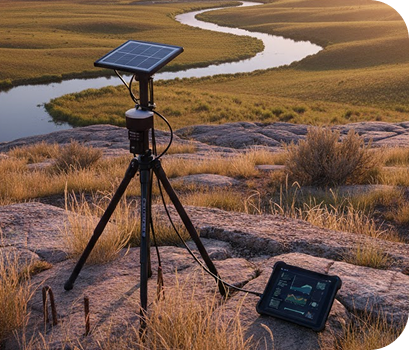
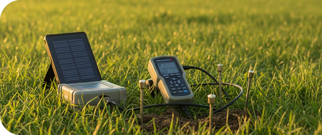
Environmental surveillance buoys are autonomous, sensor-integrated floating systems that provide continuous real-time data on aquatic ecosystems. Equipped with advanced telemetry, these platforms are built to monitor a range of parameters such as water quality, meteorological data, and hydrodynamic behavior. Deployed in lakes, rivers, coastal waters, and offshore locations, they play a vital role in safeguarding ecosystems, supporting compliance, and enabling science-based decision-making.Powered by solar energy and connected via satellite or cellular networks, these buoys ensure uninterrupted data transmission even in remote environments.
Environmental Telemetry Devices
Environmental Telemetry Devices provides specialized buoy systems tailored for complex environments across North America. As a B2B-focused technology leader based in San Francisco, CA, we combine in-house engineering with trusted global technology partnerships to offer rugged, scalable, and intelligent solutions. Our environmental surveillance buoys are built on a foundation of innovation, reliability, and expert support—delivering precise data when and where it matters most.
Core Components
Hardware
- Buoy Platforms: Utilized with LoRaWAN Accessories to enable modular integration of marine-deployed sensor systems within long-range telemetry networks.
- Environmental Sensors: Aligned with Environmental & Agriculture Sensors, offering multi-parameter aquatic and atmospheric sensing capabilities tailored to complex field conditions.
- Weather Sensors: Integrated using BLE Gateways, Beacons & Accessories to facilitate low-energy, short-range weather data transmission in hybrid station architectures.
- Power System: Powered through our Solar Power solutions to ensure continuous, off-grid operation of floating or remote monitoring stations.
- Telemetry Modules: Supported by Cellular IoT Devices, enabling resilient long-range communication across cellular, satellite, and radio networks in diverse deployment environments.
Software
- User Interface: Web-based and mobile-friendly dashboards with real-time alerts, data visualization, and analytics tools.
- Data Management: Time-series data storage, automated data cleaning, and sensor calibration tracking.
- Configurable Alerts: Custom thresholds with SMS/email/push notifications for abnormal readings.
Cloud Services
- Secure Cloud Hosting: End-to-end encryption, automated backups, and compliance-ready storage.
- Data APIs: RESTful APIs for integration with GIS platforms, third-party software, or enterprise SCADA systems.
- AI/ML Analytics: Predictive modeling for trend detection, anomaly identification, and impact forecasting.
Technology Portfolio and Trusted Partners
In addition to offering products and systems developed by our team and trusted partners for Environmental Surveillance Buoys, we are proud to carry top-tier technologies from Global Advanced Operations Tek Inc. (GAO Tek Inc.) and Global Advanced Operations RFID Inc. (GAO RFID Inc.). These reliable, high-quality products and systems enhance our ability to deliver comprehensive technologies, integrations, and services you can trust. Where relevant, we have provided direct links to select products and systems from GAO Tek Inc. and GAO RFID Inc.
Key Features and Functionalities
- Autonomous, long-duration deployment (30+ days without maintenance)
- Anti-biofouling coatings and ultrasonic cleaning for sensor longevity
- Redundant telemetry for guaranteed data delivery
- Easy sensor interchangeability and modular upgrades
- Integrated GPS for real-time location and movement tracking
Integrations and Compatibility
- Compatible with third-party sensors from brands such as YSI, RBR, Turner Designs, and more
- Interoperable with SCADA, ArcGIS, EPA data portals, and marine navigation systems
- Seamless integration with data aggregation hubs, field tablets, and wireless relay stations
- Supported formats: CSV, JSON, XML, NetCDF
Benefits
- Enables real-time decision-making in sensitive and remote water bodies
- Reduces operational costs through automation and remote diagnostics
- Supports regulatory reporting with continuous, verifiable datasets
- Strengthens environmental protection and emergency response strategies
- Improves research outcomes with high-resolution temporal and spatial data
Applications
- Water quality monitoring in drinking water reservoirs and treatment zones
- Environmental impact assessments for mining, dredging, and offshore drilling
- HAB (Harmful Algal Bloom) early warning systems in freshwater and marine environments
- Fisheries management and aquaculture condition tracking
- Flood forecasting and hydrological research
Industries Served
- Environmental Agencies
- Utilities & Water Management Authorities
- Oil & Gas
- Mining & Natural Resources
- Research Institutes and Universities
- Emergency Response and Disaster Management
- Port Authorities and Maritime Operations
- Agriculture and Aquaculture
Relevant U.S. & Canadian Industry Standards and Regulations
- EPA Clean Water Act (CWA)
- NOAA National Water Quality Monitoring Council Guidelines
- U.S. Army Corps of Engineers EM 1110-2-1201
- Canadian Environmental Protection Act (CEPA)
- Canadian Council of Ministers of the Environment (CCME) Guidelines
Case Studies
Chesapeake Bay, Maryland
To combat nutrient pollution and algal blooms, Environmental Telemetry Devices deployed three environmental surveillance buoys across critical Chesapeake Bay tributaries. Equipped with multi-parameter sondes and meteorological sensors, the system delivered real-time data to state agencies and academic researchers, enabling immediate responses to oxygen depletion zones and long-term trend analysis.
Mississippi River Delta, Louisiana
A consortium of environmental consultants and energy companies used our buoy systems to monitor salinity, turbidity, and sediment transport during dredging operations. The buoys helped ensure compliance with environmental regulations while providing data to optimize dredging schedules and reduce downstream impacts.
Lake Ontario, Ontario
Our Canadian client, a government-funded environmental monitoring program, installed a grid of four buoys in Lake Ontario to detect nutrient load, track algal blooms, and study thermal stratification. The platform’s integration with satellite telemetry allowed uninterrupted data flow in remote areas with limited cellular coverage.
Looking to deploy environmental surveillance buoys for your next project?
Contact us to request a custom quote, schedule a demo, or consult with our experts. We're here to help you navigate complex environmental challenges with smart, scalable technologies you can trust.