
Drone-Based Environmental Samplers for Advanced Field Data Collection
Autonomous drone systems for efficient, precise environmental sampling in hard-to-reach or hazardous areas
Drone-Based Environmental Sampling Solutions for Accurate Real-Time Field Data
Drone-based environmental samplers are transforming how field data is collected in remote, hazardous, or expansive environments. These systems leverage unmanned aerial vehicles (UAVs) equipped with specialized sensors and sample collection modules to monitor air, water, soil, and vegetation with greater efficiency and precision than traditional methods. Ideal for time-sensitive environmental studies, emergency response, and regulatory compliance, drone-based sampling reduces risk, accelerates data delivery, and improves spatial coverage.By integrating GPS, real-time telemetry, and AI-driven analytics, these drones deliver accurate environmental insights directly to cloud platforms for immediate analysis.
Environmental Telemetry Devices
Environmental Telemetry Devices offers robust and customizable drone-based sampling platforms designed for B2B use across North America. Our systems combine real-time telemetry, autonomous flight control, and cloud connectivity to deliver actionable insights from the air—fast, safely, and securely. As a trusted provider based in San Francisco, CA, we continue to lead the field in innovation, product reliability, and customer-focused solutions, empowering businesses and agencies to gain critical environmental intelligence at scale.
Core Components
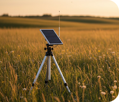
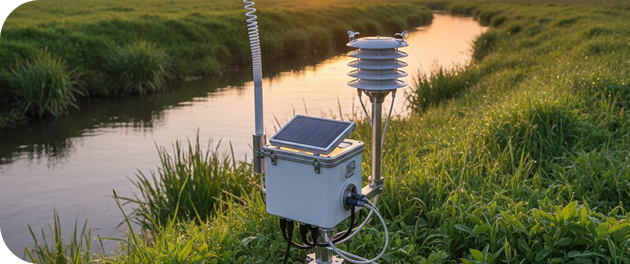
Hardware
- Multirotor and Fixed-Wing UAVs
Device Edge– supports onboard processing and telemetry in aerial WSN deployments for remote data acquisition. - Sample Collection Modules
IoT Accessories – integrate with drone-based WSNs to automate environmental sample collection in air, water. - Environmental Sensors
Chemical and Gas Sensors – enable precision monitoring of pollutants and climate variables within distributed wireless sensor networks. - Flight Controllers
GPS IoT Trackers/Devices – ensure autonomous navigation and positioning accuracy in UAV-enabled remote telemetry systems.
Software
- Autonomous route planning and waypoint programming
- Cloud-sync for flight logs, telemetry, and sample data
- Sensor calibration tools and device diagnostics
- Real-time video and data streaming dashboards
Cloud Services
- Mission reporting and compliance documentation
- Secure API access for enterprise system integration
- Historical data visualization and trend analysis
- Centralized device management and firmware updates
Our Technology Partners
In addition to offering products and systems developed by our team and trusted partners for Drone-Based Environmental Samplers, we are proud to carry top-tier technologies from Global Advanced Operations Tek Inc. (GAO Tek Inc.) and Global Advanced Operations RFID Inc. (GAO RFID Inc.). These reliable, high-quality products and systems enhance our ability to deliver comprehensive technologies, integrations, and services you can trust. Where relevant, we have provided direct links to select products and systems from GAO Tek Inc. and GAO RFID Inc.
Key Features and Functionalities
- Autonomous environmental sampling in inaccessible or hazardous terrain
- Interchangeable payloads for multi-purpose missions
- Ultra-low-altitude flight for enhanced ground-level accuracy
- Geo-referenced sample tracking and time-stamped data logging
- AI-assisted flight path optimization and obstacle avoidance
- End-to-end encryption and data redundancy
Integrations and Compatibility
Our drone-based systems integrate seamlessly with:
- GIS platforms for geospatial mapping and analysis
- EPA, NOAA, and other regulatory compliance systems
- Private and public cloud storage solutions
- Agricultural and forestry management software
- Emergency response and disaster management platforms
Benefits
- Rapid Deployment: Launch in minutes without extensive infrastructure
- Lower Risk: Keep personnel out of dangerous or contaminated areas
- Higher Coverage: Collect data over large or difficult terrain in a single mission
- Real-Time Intelligence: Access live environmental data for faster decisions
- Versatility: Reconfigure drones for various sampling and monitoring tasks
Applications
- Post-disaster environmental assessments
- Industrial emissions sampling and air quality checks
- Water sampling in lakes, rivers, and wetlands
- Soil and vegetation analysis in agriculture and forestry
- Mine and quarry air quality monitoring
- Coastal and marine ecosystem surveys
- Urban heat island and pollution pattern mapping
Industries Served
- Environmental Monitoring & Research
- Energy & Utilities
- Agriculture & Forestry
- Mining & Extraction
- Public Safety & Emergency Response
- Construction & Infrastructure
- Aerospace & Defense
- Water Resource Management
- Oil & Gas Exploration
- Transportation & Logistics
- Maritime & Coastal Surveillance
- Disaster Management & Humanitarian Aid
Relevant U.S. & Canadian Industry Standards and Regulations
- FAA Part 107 Commercial Drone Operations (USA)
- EPA Environmental Monitoring Protocols (USA)
- OSHA Drone Safety Guidelines (USA)
- Transport Canada RPAS Regulations (Canada)
- NIST UAS Data and Cybersecurity Guidelines (USA)
- FCC Part 15 – Radio Frequency Device Compliance (USA)
Case Studies
Wildfire Aftermath Assessment
In northern California, an environmental agency used our drone-based air sampling units to monitor post-fire air quality, collecting VOCs and fine particulate data over a 40-square-mile area. The system enabled faster EPA reporting and informed public safety alerts during re-entry efforts.
Industrial Compliance Monitoring
An oil refinery in Texas utilized our drones to perform perimeter air sampling and emissions tracking, replacing manual ground sampling with a more consistent, automated solution. The data helped identify two minor leaks early and contributed to full compliance during an environmental audit.
Lake Water Sampling
In British Columbia, a conservation group deployed our drone-based water samplers to collect lake surface and subsurface samples during algae bloom season. The UAVs provided time-efficient, consistent sampling across multiple sites and integrated seamlessly with cloud-based lab reporting tools.
Looking to deploy drones for smarter environmental sampling and monitoring?
Contact us today to explore custom drone solutions, schedule a consultation, or request a product demonstration. Let us help you reach new heights in environmental data collection.